
2. Table Mountain - South Africa
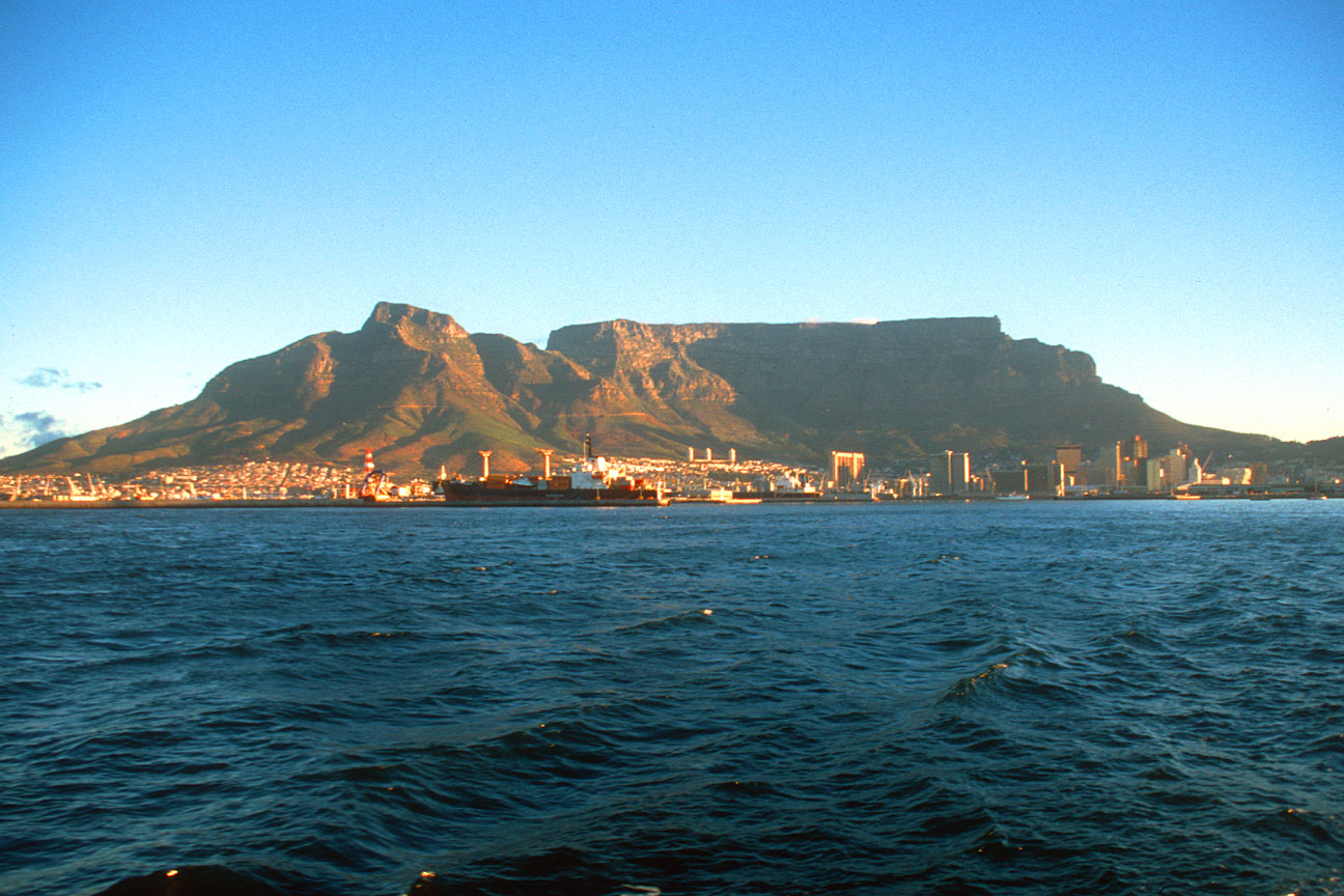
Table Mountain is a flat-topped mountain forming a prominent landmark overlooking the city of Cape Town in South Africa, and is featured in the flag of Cape Town and other local government insignia. It is a significant tourist attraction, with many visitors using the cableway or hiking to the top. The mountain forms part of the Table Mountain National Park.
The main feature of Table Mountain is a level plateau approximately 3 kilometres (2 mi)from side to side, surrounded by steep cliffs. The plateau, flanked by Devil's Peak to the east and by Lion's Head to the west, forms a dramatic backdrop to Cape Town and its Table Bay harbour, and together with Signal Hill form the natural amphitheatre of the City Bowl.
The highest point on Table Mountain is towards the eastern end of the plateau and is marked by Maclear's Beacon, a stone cairn built in 1865 by Sir Thomas Maclear for trigonometrical survey. It is 1,086 metres (3,563 ft) above sea level, about 19 metres (62 ft) higher than the cable station at the western end of the plateau.
The flat top of the mountain is often covered by orographic clouds, formed when a south-easterly wind is directed up the mountain's slopes into colder air, where the moisture condenses to form the so-called "table cloth" of cloud.
3. Autana Tepui - Venezuela

Autana, the tree of life, is a spectacular tepui located in the Amazonas state in Venezuela, part of the Guiana Shield. It stands 1,220 m (4,000 ft) above sea level. A unique cave runs from one side of the mountain through the other.
4. Ptari Tepui - Venezuela

Ptari Tepui's sheer rock walls are so isolated, it is believed a high number of endemic plant and animal species could be found there.
5. Ben Bulben - Ireland
_fs.jpg)
Ben Bulben is a large rock formation in County Sligo, Ireland. It is part of the Dartry Mountains, an area sometimes called "Yeats Country". Ben Bulben is listed as a protected structure. Ben Bulben was formed during the Ice age, when large parts of the Earth were under glaciers. It was originally merely a large ridge, however the moving glaciers cut into the earth, leaving a distinct formation, now called Ben Bulben.
Ben Bulben hosts a unique variety of plants, possessing some organisms found nowhere else in Ireland. Many are arctic-alpine plants, due to the mountain's height, which allows for cooler temperatures than is normal. These plants were deposited when the glaciers that created Ben Bulben melted. Insects, wild hares, and foxes inhabit Ben Bulben.
6. Auyantepui - Venezuela

Auyantepui which in the language of the native Pemon people means "Devil's Mountain", is the most visited and famous tepui (table-top mountain) in Venezuela. It is one of the largest (but not the highest) tepuis with an area of 700 km² in the Guayana Highlands and is located in the Gran Sabana region in Bolivar State. Angel Falls, the highest waterfall in the world, drops from a cleft near the summit. The falls are 979 meters (3,212 ft) high, with an uninterrupted descent of 807 meters (2,648 ft).
7. Grand Mesa - USA

The Grand Mesa is a large geologic formation in western Colorado in the United States. The largest mesa in the world, it has an area of about 500 square miles (1300 km²) and stretches for about 40 miles (65 km) east of Grand Junction between the Colorado River and the Gunnison River, it's tributary to the south. The north side of the mesa is drained largely by Plateau Creek, a smaller tributary of the Colorado. It rises about 5,000 feet above the surrounding river valleys, including the Grand Valley to the west, reaching an elevation of about 11,000 feet (4,000 m), with a maximum elevation of about 11,237 feet (Crater Peak). Much of the mesa is within Grand Mesa National Forest. Over 300 lakes, including many reservoirs created and used for drinking and irrigation water, are scattered along the top of the formation.

Mount Conner, also known as Attila and Artilla, and occasionally found as Mount Connor, is a mountain reaching to 859 m (2,818 ft) above sea level and to 300 m (984 ft) above ground level. It is located southeast of Lake Amadeus in the southwest corner of the Northern Territory, 88 km (55 mi) east-southeast of Uluru/Ayers Rock at the border of the vast Curtin Springs cattle station. Mount Conner is a flat-topped and horseshoe-shaped inselberg, part of the same vast rocky substrate thought to be beneath Uluru/Ayers Rock and Kata Tjuta/Olgas. It can easily be confused with Uluru, since it can be seen from the road to Uluru and Kata Tjuta, when approaching from Alice Springs. It was named Mount Conner by William Gosse in 1873 after M. L. Conner, a South Australian politician who assisted many of the early settlers in Australia.

Kukenan is a tepui in Guayana Region, Venezuela. It is 2,680m (8,793 ft) high and about 3 km (1.9 mi) long. The 674m (2,211 ft) Cuquenan Falls is located at the south end of the tepui.Kukenan is located near Mount Roraima, a much more famous tepui to the north-west. It is more difficult to climb, so it is ascended much less frequently than Mount Roraima.
10. Sarisariñama - Venezuela

The Sarisariñama tepui is a mountain in the Jaua-Sarisariñama National Park at the far south-west of Bolívar State, Venezuela, near the border with Brazil. Altitude: 300 - 2,350 metres. The name of the mountain originates from the tale of local Ye'kuana Indians about an evil spirit living in caves up in the mountain and devouring human flesh with a sound "Sari... sari...". The tepui is in one of the most remote areas in the country, with the closest road being hundreds of miles away.

2 comments:
Thanks for sharing this nice blog..
Venezuela Holidays 2014
Thank you for adding the valuable information about the mountain...
Post a Comment